“NATO as an Alliance enabled by space relies on national and commercial space capabilities to support its missions and operations.”
Schriever Wargame 2012 International
Introduction
The strategic advantage that space capabilities provide to NATO-led operations has been described and underlined in a variety of publications, strategy papers, and exercises like the Schriever Wargame 2012 International. The scope of any combined space operation that NATO forces engage in will be driven by civil, military, and commercial players.1 Space services provide a set of tools to support and meet mission requirements and commander´s objectives. Commercial space services are already integral across a full spectrum of military operations with a focus on C4ISR and Geo-Information. These services can bolster available space capabilities at the time needed in a respective area of interest, providing a ‘diversity of capabilities’ and thus potentially reducing vulnerability. The article will focus on some emerging commercial services in Germany which are being driven by innovative next generation radar and laser technology.
Precise Global Elevation Information
Precise elevation data is the initial foundation of any accurate geospatial product, particularly when the integration of multi-source data is performed based upon it. The accuracy of the base Digital Elevation Model (DEM) is key to successful mission planning and operation. A new seamless homogeneous high quality standardised elevation model for the Earth´s entire land surface will be available upon 2014. The so-called ‘WorldDEMTM’ will provide global coverage with a unique quality and accuracy of 2 m (relative) / better than 10 m (absolute) in a 12 m x 12 m raster. The accuracy will surpass that of any global satellite based elevation model available today. WorldDEMTM is intended to be the replacement data set for the current SRTM standard (SRTM = Shuttle Radar Topography Mission) and is a quantum-leap in global elevation modelling. The data basis for the WorldDEMTM is being acquired since 2010 by the German radar satellites TerraSAR-X and TanDEM-X which form a unique high-precision radar interferometer in space (figure 1). The two radar sensors acquire absolutely reliable data as they operate independent of cloud and lightning conditions. The key advantage of this satellite-based data acquisition is the generation of a global DEM with no break lines at regional or national borders and no heterogeneities caused by differing measurement procedures or campaigns staggered in time. The mission has been implemented in the frame of a Public Private Partnership between the German Aerospace Centre (DLR) and Astrium. The WorldDEMTM will enhance a wide range of applications, from orthorectification and base topographic mapping to the more specialised geospatial needs of defence, homeland security, intelligence and military engineering interests. It will provide detailed terrain information and hydrology data for surveillance, reconnaissance and mission planning. The 3D nature of the data provides an ideal visualisation tool indispensable for military and intelligence planning and rehearsing of complex missions. Military personnel can rely on accurate information about the natural and built environment including elevation, infrastructure, vegetation and water bodies anywhere on the globe. The data facilitates the assessment and interpretation of landscapes with exceptional detail, supports mobility options planning, inclusive mapping of obstacles that can stop, impede, or divert military movement, and supports the assessment of military engineering projects.
Military Aviation, manned and unmanned, is another area where the WorldDEMTM can make a valuable contribution. The highly precise and globally available DEMs combined with airfield information provide improved input data for collision avoidance systems, ground proximity warning and flight management systems. It supports flight path and landing area planning even in remote and difficult to access areas.
The global availability of the dataset with full homogeneity and seamlessness will enhance international cooperation and cross-border mission planning. Particularly when the rapid provision of accurate information is of utmost importance, e.g. in case of an emergency situation). The dataset can support the improvement of emergency preparedness measures by supporting e.g. reliable flood modelling to calculate risks and evaluate exposed areas. In a crisis situation rescue teams on the ground can rely on accurate elevation information for the rapid implementation of response measures incl. damage assessment and planning of access and evacuation routes.
Astrium Services / Infoterra GmbH holds the exclusive commercial marketing rights for the WorldDEMTM and is responsible for the adaptation of the elevation model to the needs of commercial users worldwide. Astrium will refine the DEM according to customer requirements, e.g. editing of water surfaces or processing to a Digital Terrain Model. There will most probably be a military DEM editing alliance in future initiated by the German BGIO (Bundeswehr Geo Information Office) and with involvement of many NATO nations. More information about the WorldDEMTM and sample data can be found on the respective Infoterra website.
WorldSAR – A Next Generation Very High Resolution X-Band Radar Constellation
TerraSAR-X (TS-X) Services commenced in January 2008, providing a commercial space based radar capability with a spatial resolution down to 1 m and featuring a pixel location accuracy of less than 1 m. TanDEM-X (TD-X), a TS-X rebuilt, was launched in 2010 to fly in close formation with TS-X and to allow for across track interferometry to establish a global level 3 DEM (as described above). Besides that, the TD-X satellite is also used for nominal imagery. Several Ministries of Defense of NATO nations already belong to the user community of TS-X / TD-X services including the U.S. National Geospatial Intelligence Agency (NGA) and the German BGIO.
To comply with increased requirements in data refreshes, especially from the Maritime and Emergency Response Services segments, Astrium Services / Infoterra GmbH has constantly been upgrading TerraSAR´s ground station network access. As a benefit, especially through improved polar station access and processing capabilities, Near Real Time (NRT) delivery requirements can be served since early 2012. The almost identical Spanish-built PAZ satellite will be launched in early 2014 and injected into the TS-X reference orbit. Astrium and Hisdesat (operator of PAZ) will establish a constellation approach with TS-X / TD-X and PAZ aiming to improve revisit and enable new interferometric services (figure 2). The constellation will secure continuity of TS-X services until the Next Generation of TS-X satellites will be available.
Lessons learned from more than five years of operating space-based commercial Synthetic Aparture Radar (SAR) systems along with the related user community and stakeholder feedback have led to the TS-X Next Generation (NG) based constellation concept called ‘WorldSAR’. The objective of WorldSAR is to provide NRT remote sensing information on a global scale, based on advanced SAR sensor technology allowing a spatial resolution down to 0.25 m and based on chirp bandwidth extended to 1,200 MHz. Besides the advanced Very High Resolution modes the TS-X NG satellite will provide heritage modes ensuring data continuity for established applications like continuation of existing data stacks and interferometry. Improved wide swath modes will support large area applications, like open ocean surveillance. WorldSAR is a weather independent high quality SAR satellite constellation with NRT data access supported by a high-speed workflow / processing capability, providing an information latency of 15 minutes or better. The WorldSAR will provide end-users (civilian or military) with high resolution SAR data and quick mission response due to access to the entire constellation.2 The WorldSAR constellation is scheduled to be operational upon 2018 (figure 3, p. 38), providing a variety of Very High Resolution SAR products in NRT availability as described above to a broad user community including military end-users.
SpaceDataHighway – Minimising Information Latency
The combination of radar satellite TS-X NG with a bidirectional high-speed data transfer capability will revolutionise the way we monitor and disseminate data.
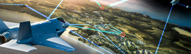
The unprecedented performance options for payload tasking and data download of / from satellites in Low Earth Orbit and / or Unmanned Aerial Systems (UAS) will make data available at the right time at the right place. Together these systems inaugurate the first commercial global NRT ISR Service capable of delivering actionable information in less than 20 minutes.3
The ‘SpaceDataHighway’ currently being implemented (projected 2016 FOC) by Astrium Services is a constellation of geostationary satellites which provide two-way broadband data relay services for the above mentioned NRT ISR services (figure 4). It is developed and implemented within the EDRS (European Data Relay System) Public Private Partnership program between the European Space Agency (ESA) and Astrium Services. As prime Astrium builds, owns, operates and co-finances the system´s infrastructure. Astrium also implements the data transmission services to ESA and customers worldwide. ESA is the anchor customer through the Sentinel satellite mission, i.e. the SpaceDataHighway will provide data relay services for the Copernicus /
Global Monitoring for Environment and Security (GMES) satellites, facilitating a rapid downlink of large volumes of imagery.
The SpaceDataHighway enables immediate broadband data transfer from LEO satellites and UAS to the ground with an unprecedented data rate of up to 1.8 Gigabits per second, enabling e.g. the transfer of full motion video at full rate with no rate change / choke points. Due to the state-of-the-art laser communication technology onboard the SpaceDataHighway, the probability of interception is significantly reduced. The system enables forward tasking of platforms in joystick mode resulting in a significantly improved system reactivity and flexibility. Routing the data through the SpaceDataHighway infrastructure also reduces the need for an extensive ground station network. Data from different systems used in an operation, whether it be UAS´s, manned platforms or satellites, can be routed through the same secure and high-performance infrastructure.
Operations of the SpaceDataHighway commenced with the launch of the first payload on-board a commercial telecommunication satellite at the end of 2014. The system will be enhanced with a second dedicated satellite in 2015 providing an increased field of coverage and system redundancy. Both satellites will form the initial core space infrastructure for service provision and coverage for LEO satellites and UAS flying over Europe, Middle East, Africa, Americas, Asia and the Poles. Plans to enhance the system with future spacecraft are already underway with an ultimate goal of providing complete global coverage and long-term system redundancy.
Conclusion
Recent NATO operations continue to prove the demand for reliable and precise geospatial data for military operations is high. Beside the resolution and revisit time, the determining factor for mission success is the rapid delivery of ISR data to the end user. Upcoming commercial systems and services as described above are very promising and able to complement military capabilities in support of mission requirements and commander´s objectives. Improved data quality and collection capability provided by the next-generation radar satellites will be more beneficial when combined with a space-based data relay system. Furthermore, it allows the tasking of satellites shortly before they enter the imaging area, optimising the satellite programming with the latest target area information and facilitating rapid response to activities on the ground for further investigation.
The dissemination of near-real-time images will be extended and thus potentially available directly to the warfighter. The WorldDEMTM will set the standard for global digital elevation information in the upcoming years and revolutionise geo information services. Cutting- edge next-generation radar and laser communication technology from Germany will provide capabilities facilitated by WorldDEMTM, WorldSAR and the SpaceDataHighway, and may support future NATO missions or operations.