Introduction
NATO operations rely significantly on space support services given by the member nations. One of the most essential is the Positioning, Navigation and Timing (PNT) service1, provided by the United States’ Global Positioning System (GPS) constellation.2 GPS, as defined by the Memorandum of Understanding IV, is to be used by all NATO nations.3 GPS has become a global utility comparable to the internet and does not ‘just’ provide positioning data. The most important civilian use, which is also important for the military community, is the timing signal which synchronizes communication and encryption for financial transactions worldwide; from cash withdrawals to stock exchange markets, where changes in the currency have wide impact.4 While the USA has formulated first requirements to strengthen the resiliency of GPS, NATO has additional options to improve resiliency by integrating the Galileo constellation, operated by the European Union (EU).5 This article will focus mainly on the military implications of these two Global Navigation Satellite Systems (GNSS), to ensure NATO members and policymakers are informed concerning the PNT options available to the Alliance. This article will first address the various threats to PNT services before looking at the idea of utilizing PNT receiver equipment capable of utilizing signals from multiple GNSS in combination. Secondly, it will address various technological and policy challenges facing the combination.
Threats to PNT Services
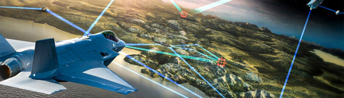
If NATO loses its PNT support it will have huge impacts on NATO military operations. However, an opponent who does not rely on GPS services may not be adversely affected. A low tech opponent may not be reliant on PNT data so he might be least affected by a denial of service. A peer opponent may operate its own PNT system, which, if intact, provides an advantage against NATO (see Table 1). This will last until NATO counters the adversary’s service with a corresponding PNT denial. These kinds of PNT warfare are summed up under the term Navigation Warfare (NAVWAR). According to Russian doctrine, for example, a highly capable PNT jamming component is included at least on the brigade level (land forces) and Russian forces are trained to fight in a degraded PNT environment.6
PNT services can be affected by jamming of the transmitted signals between satellites, ground stations and user segments within the broader spectrum of counter-space actions.7 Jamming is the intentional interference with receivers by additional signals sent from opponents’ transmitters. The aim is to overpower the satellite signal with a ’noise signal’ strong enough that the receiver is not capable of receiving the original signal anymore. Jamming attacks are typically reversible attacks.
To jam PNT services, there are a large number of different, mainly military-developed jammers available. All worldwide available space-based navigation systems are operated by the military, except Galileo, and have at least one secured frequency, reserved for governmental and military use. To jam the full service of a system requires a wideband jammer, or several jammers. Nevertheless, this means an opponent could jam the NATO GPS system, while relying on another system (see Table 1). This could cause non-usability of PNT services for NATO, while the opponent has full service. Highly capable stationary and mobile PNT signal jammers exist, and are typically used for military purposes. The antenna size and electrical power of the jammers define the range. Even very small, Commercial Off-The-Shelf (COTS) jammers, down to the size of a cigarette-box, allow short range (up to a few kilometres) jamming of at least one frequency.8 Manuals to build these kinds of systems can be found online, and the technical parts can be purchased at a regular electronics store. PNT jamming effects can also have major impacts on civilian life. PNT services are not only used in navigation devices or controlling traffic, as stated previously, they also support coordinating global financial transfers. This implies that in a jamming environment, within the jammed area, the use of Automated Teller Machines (ATMs) and stock trading would not be possible.
A more specialised type of PNT jamming is referred to as ‘spoofing’, which describes the use of higher power suppressing the original signal and replacing it with a false one. ‘Spoofing’ is most effective in smaller areas where the difference in the position is difficult to recognize by operators while monitoring other navigational options. The new signal provides ‘wrong’ signal data, which causes incorrect position calculation and/or timing.9
Besides these man-made threats there are also environmental influences. The most critical environmental effects on PNT systems are caused by space weather phenomena.10 While jamming can be overcome using countermeasures, space weather effects influence all GNSS services and may be more difficult to counter. Geographical and topographical factors could also affect signal reception by the user segments on the ground due to shadowing.
The Idea of a Combination11
On the civilian side, the access to free receivable but unencrypted (and also unprotected) GNSS signals is quite easy. Most mobile phones are already using at least two or up to four different GNSS. The US and the EU are continuing negotiations to licence civilian services provided by Galileo on the US market.12 The resulting advantages of using more frequencies have been recognized, improving the overall PNT service.13 The Transatlantic makeup of NATO already provides the Alliance with the option to use both GNSSs and take advantage of them.
Advantages of a Combination
A combination could provide greater access to GNSS, even in urban or mountainous areas where shadowing of the PNT signals is commonplace. Modern commercial PNT receivers are built to use GPS, Russia’s GLONASS and in some cases the Chinese BeiDou as well as the EU’s Galileo. Regionally there are Space Based Augmentation Systems (SBAS) integrated into local PNT Networks that supply additional correction signals. A combination of only GPS and Galileo will not increase the position accuracy, due to the very similar geometry of both systems (GPS and Galileo).14 Also, the usable area, especially north and south of 75° latitude will not be extended. Based on the fact that both systems are very similar, but rely on specifically designed reference frames, the data computation has to be done by a software solution. However, the ability to utilize both systems provides enhanced resiliency, so it is worth the effort.
Military receivers rely on protected signals. In the case of GPS, the military uses the Precise Positioning Service (PPS), based on the so-called P(Y) code, which can use two different frequencies. Galileo is protected by the Public Regulated Service (PRS) and uses two frequencies as well, different from the GPS frequencies. To gain advantages of both systems, receivers are needed that are not just able to receive both signals and calculate navigation data in parallel, but also able to combine them (e.g. position calculated out of two Galileo and two GPS satellite’s signals). On the civilian side, multiple receivers have been successfully developed for the free signals which opens the opportunity to pursue combination also in the protected military or governmental services.15 But even the option to use both of the free constellation services in parallel will increase the hardening against external influences. Parallel use of both systems could also be used as a ‘spoofing’ indicator as it always cross-checks simultaneously, and in parallel calculates positions of both GNSS. If one gets spoofed the other detects this effect and warns the user. Simultaneous ‘spoofing’ of two different GNSSs has not yet been observed and is technically more complicated. Detection of ‘spoofing’ research has been done by using an opponents’ navigation signal as an indicator.16 There is a definite need for a NATO PNT Warfare Playbook to specify measures and countermeasures.
According to the threat assessment, a combination of GPS and Galileo will increase the jamming resistance. An opponent will either have to use more jammers to affect the additional frequencies or concentrate on specific geographic areas or sectors to jam PNT signals. An area-wide jamming campaign will be harder to achieve and sustain over a long period of time.
Challenges of a Combination
To achieve a combination within a given receiver system may require additional antennas or receiver channels to accommodate the increased number of available PNT signals. The hardware of the receivers has to be adjusted, because current military PNT receivers, opposed to civilian receivers, are either only equipped with a GPS or a Galileo receiving device. Future receivers (able to use the GPS PPS as well as the Galileo PRS signal) need both receiving and decryption devices within a single system.
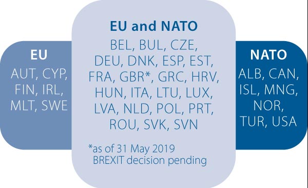
Additionally, every EU nation that uses the Galileo PRS signal is required to establish a Competent PRS Authority (CPA) which is responsible for the licensing of users inside the nation.17 Users are defined as governmental and security agencies (e.g., police, firefighters, and paramedics). By national definition, an operator of critical infrastructure could be a potential licensed user. The EU could also allow so-called third parties, non-EU nations or international organizations the use of the PRS. This decision has to be made by the whole EU in consensus. If a nation is licensed, it then has to establish its own CPA for further licensing inside the country.
In comparison to GPS, where a single nation is responsible for all security licensing procedures, Galileo has 28 responsible nations and may add even more (depending on the non-EU nations) in the future. Galileo PRS security modules must be physically produced inside the EU, licensed external production is not allowed. They are designed as a ‘Black Box’ that includes a tamper function to prevent any attempt to gain insight into the security module, either hardware or software, if breached. This regulation and function can hamper the implementation especially inside of precision-guided ammunition by national regulations or concerns of the PGM providing nation. Besides the licensing for PRS, the interoperability or standardization process has to be ongoing to implement the services in systems. It implies sustainable willingness and a lot of negotiations, and paperwork, on both sides (EU/USA) has to be done.
Summary
From the operational and technological perspective, it would be a massive improvement in PNT resiliency if both GNSS could be integrated into the NATO system. The fact that Galileo is not operated by a single nation creates challenges in the use of the PRS as well as in security issues. It will be a question for the future whether the US will modify its security standards to fully integrate Galileo inside their military receivers and into NATO Operations. The EU nations have to decide if NATO or specific NATO nations can be integrated as a ’third nation entity’ or if only the members of NATO and EU will use Galileo PNT as a national fall back. This indicates that in the midterm perspective presumably only national ‘island’ solutions will improve the PNT resiliency. If this will not be a show stopper in standardization and interoperability and positive negotiations either in the Galileo or the GPS licensing process are done, it will be an effective and successful option on the long term, either for the whole alliance or for several nations. For future challenges and threats to NATO, it seems to be crucial to understand the technological and policy options available.