Introduction
Modern societies are increasingly reliant on space-based services. Positioning, Navigation and Timing (PNT), satellite imagery, and long-distance communications to include media broadcasting as well as the World Wide Web are only few examples of the wide spectrum of services on which civil and military actors rely. This also means large numbers of related assets are deployed in Space surrounding the globe, which leads to the well-known concern that Space is becoming increasingly ‘contested, congested and competitive’.1
Developing Space capabilities is usually very time-consuming and costly, turning these space systems into invaluable assets requiring protection against the manifold natural and artificial threats to which they are vulnerable. The safety of satellites and even the long-term sustainability of outer space activities are endangered by the presence of space debris and other objects coming from the space environment. ‘Space weather’ is another concern, as disturbances stemming from the sun or outer space deliver subatomic particles and high-energy electromagnetic radiation that can severely affect the performance of space-based services as well as the functional capability of electronic devices, both in space and on Earth. This amplifies the need for so-called Space Situational Awareness (SSA).
SSA can be defined as prompt and detailed data collection about the space environment and activities to support current and predictive assessment of space systems status and of any potential threat related to Space. Every nation with space ambitions recognizes the requirement for SSA. For this reason, various Space Surveillance and Tracking (SST) facilities are currently in development by the US and European nations, with plans to improve SSA through shared data, information and services. These efforts are critical to NATO as well as to individual member nations and the Alliance should make it a point to get involved where possible.
Space Surveillance and Tracking (SST)
SST is the survey, tracking, analysis, identification, and cataloguing of active and inactive satellites and other man-made debris (fragments of satellites, launchers, junk coming from space missions) that orbit the Earth. The main aim of SST is to detect such objects and predict their trajectory in order to provide an assessment of the risk they pose for space activities. In fact, even a small piece of debris constitutes a considerable threat to space assets, due to the high speed and resultant kinetic energy that makes it a dangerous projectile. SST makes it possible to manoeuvre at-risk space assets out of harm’s way, assuming they have the necessary remote steering capabilities.
Besides this kind of space safety, SST can also be exploited for additional purposes, such as re-entry prediction. Every space object in lower orbits will eventually fall back to Earth due to the atmospheric drag, which is the deceleration caused by the contact with atmospheric molecules. Given this hazard scenario, the ability to forecast the impact zone of larger debris that will not burn up during re-entry can be critical for the population’s safety.
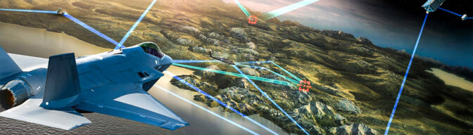
Another interesting application of SST is the prediction of satellite overflights. For the military, this is important for planning both intelligence and counter-intelligence operations. Based on the intervals when space-based Intelligence, Surveillance, And Reconnaissance (ISR) assets are expected over an area, intelligence collection can be better managed. Conversely adversary satellite detection of operations in an area can be avoided by scheduling mission execution times accordingly. Yet another possible application, useful for both military and civil actors, is the prediction of Global Navigation Satellite System (GNSS) precision, i.e. of the effect known as Position Dilution of Precision (PDOP). In fact, positioning precision strongly depends on the number and the distribution of the GNSS satellites available in a specific area at a specific time.
SST in the US and in Europe
The US has undoubtedly one of the most significant footprints in space. Therefore they need the best possible SSA at their disposal. For this reason, the US invested substantially in SST capabilities to build a Space Surveillance Network (SSN) that spans the globe. Three 1-metre Ground-based Electro-Optical Deep Space Surveillance (GEODSS) telescopes, one 0.5-metre Moron Optical Space Surveillance (MOSS) telescope, one 3.5-metre Space Surveillance telescope, a mechanically steered 27-metre dish antenna radar (Globus II) and several phased-array radars are only a small excerpt of the world-wide US SSN. In January 2014, it was composed of 29 sensors of various types,2 and an additional ‘Space Fence’ of radar SST sensors should be in operation by 2018.3
For the same reason, several European space-faring countries decided to develop their own SST capability. Today, for example, France uses the bi-static VHF radar GRAVES (Grand Réseau Adapté à la Veille Spatiale – Large Network Adapted to the Space Watch), which has been operational since the end of 2005, for low-orbit space object surveillance. Germany owns a radar-tracking capability based on the 34-metre parabolic dish antenna Tracking and Imaging Radar (TIRA) system, which can precisely determine space object orbits and derive their physical features using high resolution imaging. Finally, Italy has some processing and optical sensor capabilities and it is implementing a complete network of optical and radar sensors for surveillance and tracking covering low, medium, and geostationary Earth orbits (LEO, MEO and GEO), which includes the Matera Laser Ranging Observatory (MLRO). Such facility can measure with remarkable precision the distance to artificial satellites equipped with retroreflectors.4 Furthermore, based on laser illumination of debris, a fairly new and promising technology, laser ranging will also be capable of accurately determining the distance to other, non-cooperative targets.5, 6
Sharing is Caring
As the example of the US SSN demonstrates, the acquisition of an adequate autonomous SST capability is a massive and extremely costly undertaking for a single nation. For this reason, many friendly countries seek collaborative solutions aiming at reducing the requirement for new national SST assets through the exploitation of shared data and information that has been collected by already deployed capabilities. Several bilateral data exchange agreements are therefore in place, such as between Italy and the US7, France and the US,8 Germany and the US,9 and France and Germany.10 Moreover, since 2009, a number of European Member States (currently 18) have combined their efforts for a European SSA project through the European Space Agency (ESA) – an organization coordinating European space research and technology as well as applications.11 Even the ESA – owning several satellites – has been cooperating with the US since 2014 to solve its SSA data demand through the USSTRATCOM SSA Sharing Program.12
EU ‘Framework for Space Surveillance and Tracking Support’
It is worth noting an effective SST capability not only involves acquiring data about space objects, but also combining data from different sources (data fusion), analysing that data and extracting useful information (conjunction or re-entry predictions), and disseminating the information, managing the whole process as a service. An example of an additional but still essential SST facility is the Conjunction Analysis and Evaluation Service, Alerts and Recommendations (CAESAR), provided by the French Space Agency based on ‘Conjunction Data Messages’ distributed by the US Joint Space Operations Center (JSpOC). This service allows the analysis of space conjunctions (foreseen close approaches for active satellites), the evaluation of the relevant risk of collision, and the dissemination of tailored alerts to the satellite owners.
With the goal of developing a holistic approach capable of coping with such complexity, the European Parliament established in 2014 the so-called ‘Framework for Space Surveillance and Tracking Support’, to ‘contribute to ensuring the long-term availability of European and national space infrastructure, facilities, and services, which are essential for the safety and security of the economies, societies and citizens in Europe’.13 This support framework aims at establishing ‘an SST capability at European level and with an appropriate level of European autonomy’14 through the creation of a European SST sensor network, SST data processing and SST functional services. This framework is not meant to develop new sensors but to integrate the existing ones in order to minimize expenditure and time spent on further capability deployment. The countries participating in the project usually have their national space agencies join the respective SST consortium, which initially consisted of five countries: France, Germany, Italy, Spain, and UK. The European Union Satellite Centre (SatCen), based in Torrejón de Ardoz, near Madrid, will act as the central SST service provider.
Why Would SSA/SST Matter to NATO
The 2014 report on NATO dependencies on space concluded: ‘No single NATO operation without Space’.15 It is a strong statement reflecting the current relevance of space from a NATO perspective. As a matter of fact, space support to operations is today essential, as it is considered ‘a potent force multiplier’.16 Notwithstanding, since 2010, NATO no longer owns any space assets,17, 18 and it strongly relies on space-based services provided by Alliance Nations on a voluntary basis.19 However, this does not mean NATO commanders do not need any SSA. Obviously, a commander in operations has no need to know the position of every single piece of space debris, but he definitely should be notified whether any space environment hazard is going to impact the space-based capabilities he relies on, so timely mitigation measures can be applied. Moreover, the detailed Recognised Space Picture, which includes predicted own and adversary satellite overflights (as discussed above), could be indispensable for operational and tactical planning.
Conclusion – NATO Perspective
Space is today an essential resource for conducting effective military operations and becoming aware of threats to space-based services as soon as possible can make a difference. Moreover, the availability of a detailed Recognised Space Picture is a significant aspect for military intelligence and commanders’ decision-making. For this reason, not only single nations, but also NATO as an Alliance, require SSA, which should be a primary component of a holistic NATO approach to space.
Additionally, since it is unlikely that NATO will develop its own SST network in the foreseeable future, reliance on SSA services voluntarily provided by allied nations will remain the norm. Any effort aimed at developing effective multinational SST networks to enhance SSA, like the European SST project, should be welcomed by NATO. In fact, NATO should make efforts to get involved in any multinational SST project from the outset through its respective Alliance and national representatives, even in projects intended for civilian purposes, to ensure military requirements are appropriately recognized and SST services will be provided to the military as necessary.
Clearly, awareness of the benefits of SSA can be successfully spread via an appropriate NATO Education and Training program. The JAPCC, being the Department Head for Space Support to Operations, will take a proactive and leading role in this activity. In addition to this effort, an overall NATO strategy needs to be discussed and endorsed at the political level to be effectively implemented across the Alliance. This emphasizes that NATO does require political guidance for space-related subjects and, consequently, a NATO Space Policy.