Main Characteristics of Space Systems and Their Role in Modern Warfare
Today’s modern warfare is heavily dependent on the Space Domain;1 the use of Data, Products and Services (DPS) from Space-based capabilities allows all national armed forces, to include NATO as well as potential adversaries, to achieve their objectives with increased effectiveness and efficiency, with a reduction of time and with lower risks to friendly personnel and material. This is especially true for Unmanned Aircraft Systems (UAS), which strongly rely on all types of DPS.
In the early decades of Space exploration, the two superpowers, the USA and the former Soviet Union, were the driving forces behind humanity’s push to Space beyond earth’s atmosphere, and thus reaped the greatest benefits from their endeavours. Today, there are many new members of the exclusive ‘Space-Club’ who are engaged in scientific, governmental, and economic activities. At the same time, there are also military activities in Space from a resurgent Russia, and both a rising China and India.
When talking about Space, we have to realize the term refers to the operational domain. Often, we are actually discussing Space Systems versus the operational domain, and so we have to add a modifier for specificity and clarity.
Space Systems are seen as consisting of four segments:2
- Space Segment: the satellite in orbit;
- Ground Segment: Command and Control (C2) facilities of the satellite and its payload;
- User Segment: DPS received from the payload and used by consumers;
- Link Segment: uplink and downlink of electromagnetic signals carrying C2 as well as mission data.
Only the entirety of all segments guarantees the functionality of the overall system. Failure of any one segment, whether intentionally or unintentionally, compromises the use of an entire system, which allows for more than one potential option to counter an adversary’s Space-based capabilities, and, in turn, its UAS.
The use of Space-based services brings advantages, (e.g. worldwide coverage with smaller forces, terrestrial information without violating any state’s sovereignty, no border crossing restrictions, [near] real-time transmission, unfiltered data, enabling expeditionary operations with light forces, reach-back options), as well as disadvantages (e.g. time over target, resolution, some weather conditions) and calls for exact planning (e.g. revisit rate, persistence, responsiveness) with respect to the specifics of each satellite on its respective orbit.
For this document an orbit is defined as a regular and repeating elliptical path around the earth. Typical orbits are:
- Low Earth Orbit (LEO): 200–2,000 km, approx. 100 min/orbit, for ISS, ISR (EO, Radar), weather, scientific
- Medium Earth Orbit (MEO): 2,000–36,000 km, 5-12 hours/orbit, for GNSS, some communication
- Geostationary Earth Orbit (GEO): 36,000 km, 24 hours/orbit, stationary over equator for communications, Early Warning, weather, relay
- Highly Elliptical Orbit (HEO): typical 200–40,000 km, main coverage over the Northern Hemisphere with a long dwell time, especially for communications
A full integration of all DPS, provided by Space-based assets and free from any breakage, into modern military systems will assist the effectiveness of almost all modern military operations. The Space Domain is seen as a critical force multiplier or at least as a force enabler; no single modern operation planned or executed by modern armed forces can be done without appropriate Space support.
Given this understanding of the dependencies, UAS operations in particular are highly dependent on Space-based DPS. However, the degree of dependence may vary based on the class, range, mission, and system specifics of individual UAS.
Military Space Capabilities in General
To gain an appreciation for the military use of Space-based activities, a review of the current classifications utilized by NATO is helpful, as is possible adversarial use of the Space Domain. Space activities can generally be structured into six functional areas:3
Positioning, Navigation and Timing
Space-based Positioning, Navigation and Timing (PNT) from Global Navigation Satellite Systems (GNSS) provides accurate geo-spatial positioning and timing information anywhere on or near earth. GNSS provide for multiple uses and they allow for precision and lethality in military operations.
The Global Positioning System (GPS) is an established US GNSS, initially intended for military applications, but available for free civilian use since the 1980’s. Other GNSS’s in use and/or in development are Galileo (EU), Glonass (Russia) and Beidou-III (China).4 Additionally, India’s NAVIC (Navigation Indian Constellation) or IRNSS (Indian Regional Navigation Satellite System) and the Japanese QZSS (Quasi-Zenith Satellite System) are systems with regional coverage and orientation. These are called Regional Navigation satellite systems (RNSS). This variety of systems highlights that GNSS are not limited to only NATO, and that a potential adversary could utilize other PNT information for their unmanned systems as necessary.
Moreover, all of these passive systems, meaning only the satellite is transmitting a signal, enable high-fidelity force navigation and specific military operations, such as precision strike, personnel recovery, friendly force tracking, and network synchronisation. However, there are some potential limitations to these systems due to the weakness of the signal (e.g., atmospheric influences, urban canyons, or dense vegetation), which makes interfering with the signal (i.e., jamming or spoofing) an excellent option to reduce the effectiveness of an adversary’s GNSS.
Intelligence, Surveillance and Reconnaissance
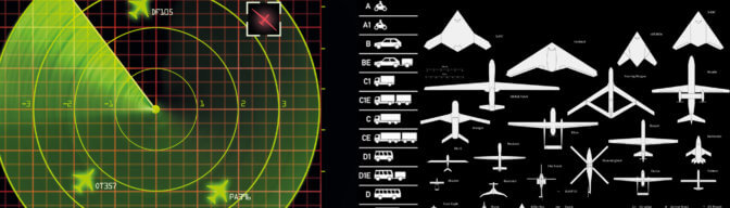
Military planning and operations require access to pertinent information. Intelligence, Surveillance and Reconnaissance (ISR) satellites are one of many means for collecting information for the intelligence community, which can be processed into targeting information for UAS operators. Electro-Optical (EO), Infrared (IR) and Synthetic Aperture Radar (SAR) are typical sensors using specific wavelengths to collect images for various purposes. Most of these satellites provide global coverage, which is valuable for preparations prior to possible conflicts. There are limitations to specific sensors in the form of resolution, coverage area, revisit times, the predictability of their orbits, as well as atmospheric disturbances.
Meteorology and Oceanography
Precise weather forecasts are necessary for planning and execution of all kinds of military operations, especially for UAS, which are generally vulnerable to adverse weather conditions. Satellites monitoring for changes in the earth’s atmosphere are one integral part of the Meteorology and Oceanography (METOC) Expert’s toolbox. In addition to terrestrial weather conditions, these satellites also monitor solar activities, which may have impacts on military operations. Electronic circuits (both within and outside the atmosphere) may be affected, and this could have a negative impact on communications, navigation accuracy, and ISR sensor capability.
Space Situational Awareness
Space Situational Awareness (SSA) is the creation of an extensive operational picture to monitor all activities in Space, including debris tracking, for operational situational awareness. This encompasses mainly threat warning and assessment, re-entry-warnings as well as the protection of satellites by avoiding collisions through the performance of manoeuvres. Overflight prediction of adversary satellites in order to provide warning to friendly forces is also an element of SSA. In short, SSA is the up-to-date awareness of what Space-faring actors are performing in, through and from Space.
Satellite Communications
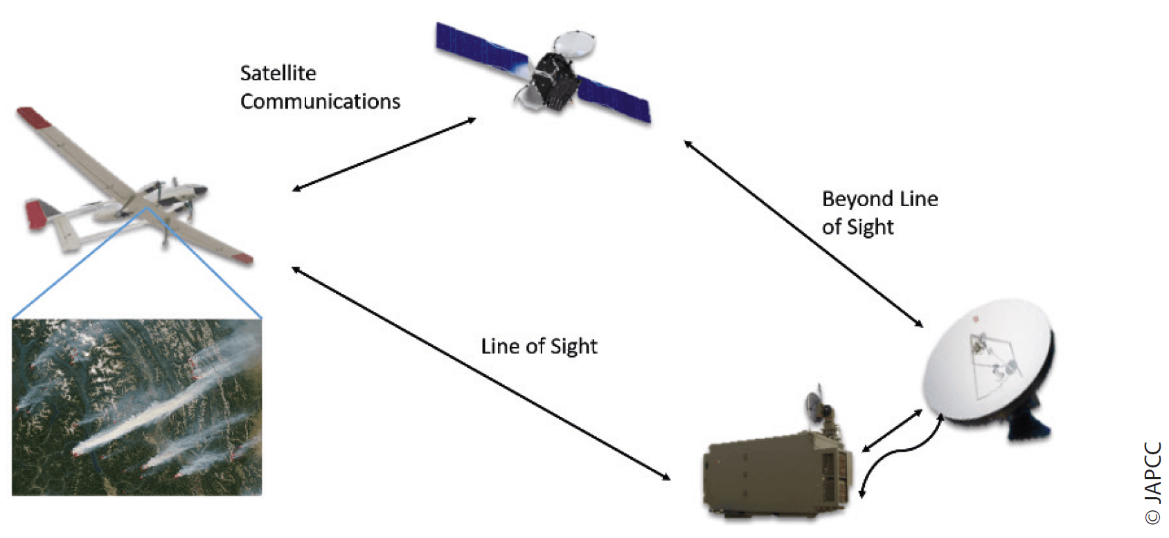
Transmission of data (texts, words, videos, etc.) via satellite is possible from any point in the world to another, with some limitations in extreme northern or southern polar areas due to the commonly used GEO orbit. To cover the extreme northern or southern polar areas satellite constellations in LEO or HEO are required. This pro-vides very flexible and secure wireless communications, especially in deployed operations and/or in areas with limited infrastructure. Satellite Communications (SATCOM) utilizes various frequency bands, each with distinct advantages and disadvantages, and some bands which are protected communication lines. SATCOM is primarily used for Command, Control and Communication (C3) purposes, and it is irreplaceable for UAS Beyond Line of Sight (BLOS) operations. SATCOM limitations may vary and are caused by limited capacity, size of antenna, available power, latency, and weather.
Shared Early Warning
Shared Early Warning (SEW) is NATO’s and allies use of US pro-vided data related to early warning of imminent missile attacks.
This is a passive part of Force Protection for friendly forces as well as NATO territory and civilian populations and similar capabilities can be expected from any other Space-faring nation.
In addition to these six capabilities, others include Space Launch and Space Operations. However, due to the fact that NATO does not own or operate any space-based resources other than some ground equipment related to satellite communications services, these are not further defined within NATO.
UAS Need for Space Support
Today, there is an enormous variety of UAS, offering different applications and tasks from simple toys to complex military systems. The dependence of these myriad individual UAS on Space-based DPS also varies greatly.
SATCOM is an essential part of all BLOS UAS operations and COTS UAS also utilize PNT signals provided by respective satellite constellations. SATCOM and PNT are the most important Space capabilities required for UAS operations and therefore are the focus of further analysis in this chapter.
Satellite Communication
Different types of UAS use different types of communications for operating the vehicle and for managing the vehicle’s payload. UAS operating BLOS are absolutely dependent on SATCOM; primarily GEO satellite networks for near real-time control.
Even UAS operating in an automated and pre-programmed mode of flight require the ability to send additional navigation commands to the air vehicle, typically in cases of mission change, and sometimes these changes are necessary on a short notice. Therefore permanent, real-time, low latency and stable Lines of Communication (LoC) are a must. In addition to the primary LoC, alternate, contingency and emergency lines should be planned for and available for critical missions. It should also be understood that these commands generally require less data and lower bandwidth than the payload. At the same time, system status of the UAS must be transmitted to the ground station, and this also calls for stable lines with a low throughput.
In addition to the Unmanned Aircraft (UA) itself, the use of the respective mission relevant payload also requires dedicated LoC. Besides the uplink of mission commands to the payload, it may be possible to downlink data collected by the payload. The capabilities of certain UAS creates opportunities and a few challenges.
Today’s more advanced and complex sensor payloads generate an ongoing growth of sensor data with an intense demand for storage capacity for high-resolution pictures (EO, IR, and SAR) and in some cases video streaming. The transmission of this data from many UA via SATCOM to their ground control stations can cause challenges to the system due to limited throughput capabilities of some SATCOM systems.
To compensate for the bandwidth limitations, data and video are often compressed, however this can result in the loss of data, depending on the techniques utilized.
Complex UAS missions, which are dependent on SATCOM, require planning with a mind-set on the communications path of the signals involved. Some of which may result in mission limitations that might affect dynamic asset re-allocation during mission execution, in turn requiring alternative solutions.
Information collected by the ISR payloads of an UAS are often time-sensitive and must be distributed across multiple military organizations, requiring each element of the LoC to be optimized to prevent a delay in data dissemination.
Currently, the main concentration of communication satellites is in the GEO belt. Research on current trends indicates in the near future we will see an increasing number of communication satellites stationed in lower orbits such as LEO or MEO which are known as ‘Mega-Constellations’ of up to several hundred satellites. They will provide a higher capacity of dataflow, the so called ‘virtual fibre’, almost anywhere around the world with less limitations than experienced today. This will offer additional primary LoC for UAS operations, as well as alternatives. Besides the developments of NATO member nations, there are also projects declared by potential opponents. China has two militarily usable systems that are currently in their technical test phase prior to their deployment. The ‘HONGYAN’ constellation5 has one test satellite in orbit and is to be planned at Full Operational Capability (FOC) in 2023. The
‘XINGYUN’ constellation6 has deployed two satellites already and is planned to be FOC in 2025. Both constellations offer frequencies that are usable for the operational control of UAS or for the sensor download-feed. Both of these constellations are operated by state-owned companies. Russia has also planned to enter this arena with the ‘SPHERA’ constellation7 a more complex system which also includes payloads other than communications. This constellation will be operated by the Russian Space Agency ROSCOSMOS. The first launch is planned for 2022 and FOC for 2028. It is very likely that the projected operational timeframes for these systems may be delayed due to several reasons. It is also very likely that due to the fact that these systems are state-owned and operated, these systems will not be cancelled due to financial problems.
Positioning, Navigation and Timing
PNT services are a substantial requirement for many types of UAS, based on their individual mission sets; even for most Class I UAS and consumer drones. This is evident for the UA itself, but this applies also for specific payloads.
If an UAS is operating in automated mode, PNT information is vital for flying the pre-planned route, as well as alternate routes or course-corrections. Likewise, if an UAS is being controlled remotely, the transmission of accurate position reports to the control element is essential for the location information and also for the timing signal shared between the ground and air segments of the UAS as they communicate via SATCOM.
For some kinds of payloads, like the employment of Precision-Guided Munitions (PGM), actual PNT-data is indispensable. ISR data collected by a variety of on-board sensors also requires an exact geo-reference for subsequent analysis and further operational use.
Space Weather and Potential Impact on UAS
In addition to atmospheric influences like clouds, heavy rain, smoke, reflections or industrial pollution, Space weather may have an impact on UAS operations.
Solar activity may result in charged particles, cosmic rays, geomagnetic storms, or solar flares, which may have an impact in various zones above the earth, through increased ionisation, higher radiation levels or signal interferences. These will result in outages in PNT and SATCOM services, which may impact an UAS indirectly, but especially UA operating at (very) high altitudes could be additionally impacted directly with the malfunction of internal power grids, digital chips or avionics.
Cases of extreme solar activities can reach into the earth’s atmosphere, which can hamper electronic devices in the ground installations and user segments of Space systems. These impacts are also potentially felt in UAS control elements, and can, to some degree, also include the LOS and BLOS data links.
Possibilities for Countermeasures Against Adversary Space Assets in Support of UAS
As discussed earlier, a complex Space system consists of four segments, which are interconnected. To interrupt the services of the whole system only one segment needs to be affected, which can be done by several types of counter-Space weapons:
Physical attacks destroy or damage Space- or ground-based Space assets through the use of systems like direct-ascent anti-satellite missiles, co-orbital anti-satellite vehicles or by attacking the ground station through various means, such as offensive counter-air operations as outlined in Chapter 8 (cf. p. 136 f.).
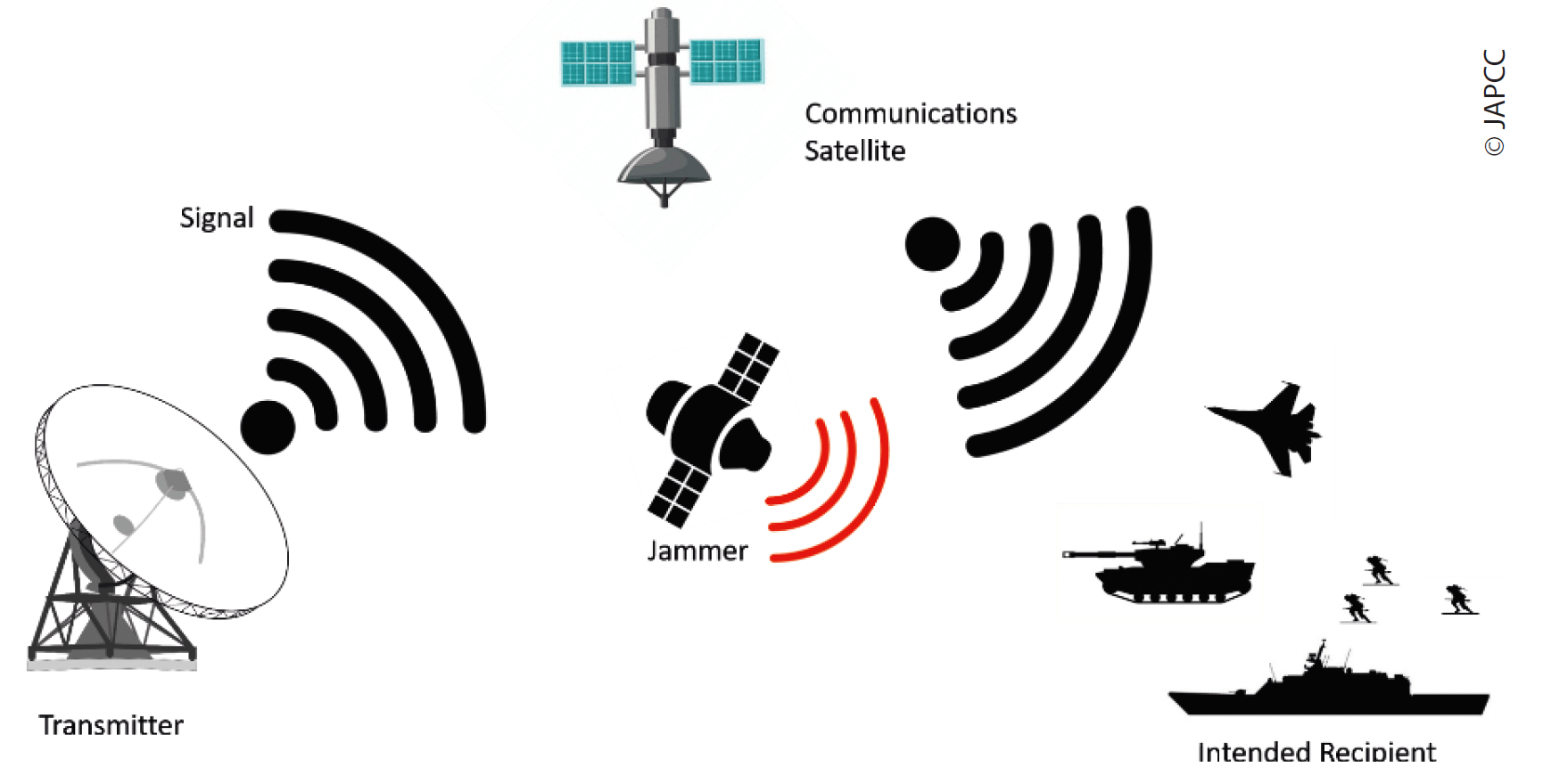
Non-physical attacks target the means of transmission by interfering with the various signals comprising the link segment. This can be done by jamming or spoofing and is usually temporary in duration.8 Chapter 10 (cf. p. 177 ff.) discusses these types of attacks in more detail.
If a single UAS mission is dependent on SATCOM Services and/or PNT Data, any effective attack against one segment of the Space-System leads to a failure of the complete Space service which consequently has an impact on the success and the flexibility of the UAS mission. However, if the UAS C2 link experiences interference, that does not automatically equate to UAS mission failure. The UAS might be able to complete its mission, but without receiving new instructions during the sortie.
Besides physically engaging the UA itself with Air Defence, or the Space-, Ground-, or User-Segment of the Space-System, non-physical attacks against the link segment provide another option to adversaries:
Jamming. Intentional interference of the link by generating a separate but stronger signal in the same radio frequency as the original system. This prevents receivers from distinguishing between the false signal and the real signal, and therefore prevents the system from processing the authentic signal and the relevant mission information it contains.
Spoofing. A more sophisticated form of jamming is imitating an authentic signal to force a receiver to process false data, which the end-user believes is real data.
Positioning, Navigation and Timing
Interfering with PNT signals requires merely some generally low-cost GPS jamming devices.9 These devices have to be located within a specific range of the GPS receivers they wish to affect. As the antennas of GPS receivers are generally omnidirectional, many avenues of attack are open for jammers on the ground or in the air. Additionally, the signal strength of any GNSS is extremely low power and therefore also vulnerable to unintentional interference.
Furthermore, jamming of GNSS also has an effect on the timing information provided by the signal; which may disrupt the link synchronisation.
Spoofing the GNSS signal may result in the UA flying far from its pre-planned flight path, without giving alarms, or even may cause the UA to crash. Forcing a consumer drone to land due to spoofing the PNT signal has already been successfully tested and it is technically possible that this method could also be used for larger military systems.10 However, this technique calls for sophisticated technology to create falsified signals to impact the UAS, especially for military-grade signals which are typically encrypted.
Satellite Communications
For communications purposes, specific military satellites provide secure and protected radio frequency signals against jamming threats. If these secure lines are not available for the armed forces, generally non-protected governmental or commercial satellites have to be used; and these signals are normally easier to attack. There are jamming techniques which have been developed to disrupt communications signals in various bands located on mobile, fixed and naval systems.
Uplink jamming prevents the satellite transponder from differentiating the jamming signal and the original signal. To be effective, the jammer must be located within the field of view of the antenna on the satellite.
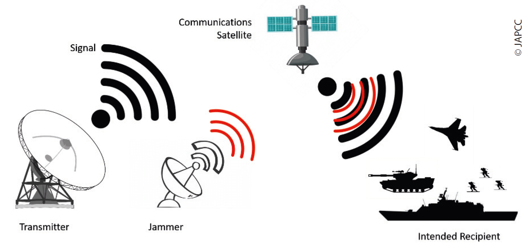
Downlink jamming disrupts the signals travelling from the satellite to the receiver. To be effective, this jammer must be within the vicinity of the receiving antenna. This type of jammer does not need to produce a very strong signal, because it only needs to be powerful enough to disrupt the reception of the signal at the ground or user node.
Due to the various characteristics of individual UAS, the impact of ground-based SATCOM jammers varies. For downlink jamming to be effective, the jammer most likely has to be in a position between the satellite and the antenna of the UAS. So, for high-altitude UA only Space-based or air-based jammers have a possibility to jam the SATCOM downlink.
SATCOM jamming is relatively inexpensive and the technology is commercially available and therefore it is not the exclusive purview of state actors. However, jamming an UA is more challenging due to the altitude, speed, range, and on-board protective measures of UA, and therefore requires more advanced technical solutions.
Other Aspects
The intentional interference of a link node is an effective means to disrupt UAS missions with generally temporary effects, which are difficult to attribute to a specific aggressor. Sometimes such an attack is not even detected, other than a mission was not successful.
These kinds of intrusion are elements of Electronic Warfare; basic information and specific aspects of which are described in Chapter 10 (cf. p. 177 ff.).
Space-based services also offer potential avenues for cyber-attacks.11 SATCOM ground terminals and control centres are usually connected via computer networks which can be exploited or disrupted. Chapter 11 (cf. p. 183 ff.) discusses cyber means which are directed against UAS components in more detail.
Conclusion
Various UAS need specific services provided by Space capabilities. The needs are dependent on class, size, level of autonomy, and the specifics of the operation or mission. In close cooperation with actual Space-based DPS, UAS are able to exploit their inherent advantages. The current and future dynamic development in many Space-based areas, such as mega-constellations of small satellites in LEO, will provide further possibilities for the operation of UAS.
However, UA are not invulnerable. In the realm of Space-based DPS for UAS operations there is a vulnerability to the impacts of counter-SATCOM and PNT services. The guarantee of PNT and SATCOM services is vital for the success of UAS operations. Denied or degraded Space support will significantly hinder UAS operations.
In order to prevent or influence the success of adversary UAS, appropriate offensive measures must be initiated, which could hamper PNT and SATCOM Services. These measures can target parts of the supporting Space system as well as directly the UAS. Detailed knowledge of the frequencies and procedures used is required in both cases, and in particular to provide the means and awareness to place the countermeasures in the position that makes success most likely.